
|
In
work that was undertaken for Mouchel Essex on behalf of Essex County
Council, Minnerva exploited the capabilities of OmniTRANS to develop
trip matrices for Chelmsford.
Roadside interview (RSI) data was available for
some of the area, but coverage was partial in nature and included
multiple observations. Using the OmniTRANS matrix estimation facilities
a procedure was established that processed the RSI data to provide
a set of observed data for the study area. This accounted for sampling
levels, unobserved trip directions, and multiple observations. The
processing encompassed the ‘MATVAL’ methodology that
merges multiple observations according to the level of sampling
(calculated as an Index of Dispersion)
Gaps in the data were filled using a mixture of
Gravity type modelling for local trips and information from a regional
study (LOIS) matrix for external trips. Trip end information for
the local area was calculated from the TRICS database and from car
park surveys. The matrices were developed not only by time period
and vehicle type, as required for the Paramics traffic simulation
modelling being undertaken in Chelmsford, but also by trip purpose.
This was a result of also using the matrix estimation procedures
of OmniTRANS that allow information on trips to be by vehicle type
and trip purpose. For example, the traffic count data used in the
estimation was variously supplied in terms of total trips (from
automatic traffic counters), by vehicle type (from manual classified
counts), and by type and purpose (in the case of RSI sites)
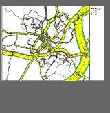
The image on the right, which shows car trips in
the form of bandwidths colour-coded by purpose, is therefore significant
in supporting not only traffic management modelling but also policy
analysis – education trips being of particular interest in
this case, as well as multi-modal modelling, for the matrices can
also be provided in terms of person trips as well as vehicle trips
The project also involved the use of GIS to enhance
the precision of the geocoded origin and destination data in the
RSI surveys and subsequent coding to traffic zones.
(Contact: Martin
Bach)
|
|
 |
